Physics Based
Modeling & Simulation
Real-Time Terrain Rendering

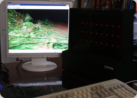
MeshSP Desktop Supercomputer - Unprocessed DTED Data to Terrain Rendering
Real-Time Volume Rendering
The following video depicts operation of a volume rendering software tool
developed for a small atmospheric research company. The windows based tool
uses DirectX and optimizations based on detected video hardware. It is customized
to read and filter Weather Research and Forecasting (WRF) datasets for viewing
such parameters as Temperature, Water Vapor, Pressure and Relative Humidity in a 3D
volume. During real-time viewing, the complete dataset can be filtered with "slider bars"
to set the min and max data clipping values, and can also be instantaneously mapped
to linear, logarithmic and exponential functions to readily analyze/enhance specific features.
Physics-Based Multiple Scattering
The following videos demonstrate a tool developed completely by waveI staff for a USAF
SBIR contract to visualize physically realistic gaseous phenonmenona. The cloud volume is
described solely by cells of Liquid Water Content (LWC) and droplet size distributions.
All cloud multiple scattering computations use Mie theory for 3 visible bands of light.
The sky is modeled as approximately 20 scattering layers and uses a dry atmosphere Rayleigh
model to attenuate light reaching the cloud volume and also directly scattered to the image plane.
The first video depicts a fixed low horizon sun location while the camera orbits a synthesized
cloud volume. Mie effects are immediately evident from 1st and 2nd order scattering effects in the
forward and back scattered directions. The ambient lighting of the volume from ground and sky
components is approximated with a diffusion model. The Glory and Fogbow effect are readily
demonstrated with the Mie model.
Historical Development
Real-Time Terrain Renderer
In the mid 1990s, waveI key members developed the first real-time terrain renderer that read raw DTED data and rendered directly to screen without pre-processing for polygon generation. We made use of the MeshSP, a "Desktop Supercomputer" developed at MIT Lincoln Labs. The MeshSP has 64 Analog SHARC processors (ADSP61062) connected in a nearest neighbor grid + 2 extra communication paths per chip. (That 7.7 GFlops platform cost $100,000 in 1996!!! Would you care to buy it?)waveI members also demonstrated the first raytracing algorithms to be implemented on the MeshSP architecture. This image depicts a buckyball configuration of 60 reflecting spheres surrounding a single reflecting sphere. Real-time demonstrations were shown at SIGGRAPH.

Real-Time Volume Renderer
Direct X Implementation
Physics-Based Multiple Scattering
Custom Renderer Using Mie Scattering


